New Web Features are Released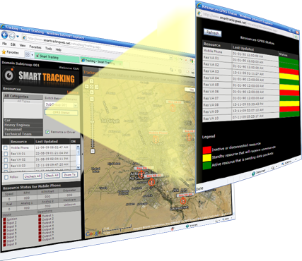
-
Enhanced Reporting Engine
New: Stops Report
We at Smart Tracking highly appreciate our clients' feedback regarding the
accuracy and dependency of the reported data.
A new Stops Report is added to the
reports family which constitutes the times the vehicle has stopped
for a duration of time dynamically specified by the user in relation to
the nearest point of interests (POIs), Streets, and Communities on the map.
-
GPRS Status
This new feature helps the user diagnose the status of the GPS devices residing inside the vehicles. The status of each device is reflected on the spot using color designations and readings from the devices. The new feature reports devices that are active and sending data, or devices that are connected in standby mode, or disconnected, which requires immediate attention if the device remains disconnected for a long time.
New Desktop Features |
- Snail trail: Resources on the map can now display trails along the last 500m path. Trails are displayed in different colors according to the violation(s) committed by the resource.
- Customer Information plus coordinates can be saved and fetched back into the map to be utilized by the application.
- Automatic Arrival Notification: The system will send an automatic arrival notification once a vehicle is within a certain distance from the anticipated location arrival.
|
|